
Articles
Urban Development
May 13, 2026


When you open a project in the Netherlands inside Hektar, the parcel boundaries, the noise contours, the rail networks, and the cadastral grid are not approximations. They are pulled live from authoritative Dutch sources via WMS (Web Map Service) protocols. This post documents every layer we currently integrate for Dutch projects, where each comes from, and why it ended up in the platform.
This kind of detail rarely makes it into product marketing. We are publishing it because the choice of data sources is one of the most consequential things a feasibility platform does, and prospects in the Dutch market deserve to know exactly what they get.
The earliest decisions on a raw land project are made in conditions of high uncertainty. The developer often does not yet know the precise parcel boundaries, the regulatory regime, the noise context, or the surrounding infrastructure constraints. Each of these unknowns translates directly into financial risk.
A wrong assumption about parcel boundaries can move a feasibility study by 10 to 20 percent on yield. A missed noise contour can disqualify a residential typology entirely. An ignored seismic risk zone can force structural changes that erase the project margin. These are not theoretical risks. They are routine causes of late-stage redesign in Dutch residential development.
The way to compress this risk is to bring authoritative data into the feasibility workflow from the first sketch. That is what data layer integration is for. The earlier the data arrives in the decision process, the less expensive every subsequent decision becomes. This is the core thesis behind our ongoing Vinnova-funded research on regulatory compliance intelligence: data and rules belong at the start of the design process, not as validation at the end.
Our 18 current Dutch layers come from three primary providers. Each was selected for a specific reason.
PDOK is the official Dutch government platform for open geospatial data, operated jointly by Kadaster, Rijkswaterstaat, and several other public bodies. It is the authoritative source for cadastral and administrative data in the Netherlands. We use PDOK because it is the legal source of truth for parcel boundaries; any other provider is, at best, a wrapper around PDOK data.
Risicokaart is the Dutch national risk map, operated by the Interprovinciaal Overleg (IPO) in cooperation with the safety regions. It catalogues hazards and infrastructure relevant to emergency planning: seismic zones, wildfire areas, rail networks, airports, tunnels, waterways. For early-stage residential feasibility, this matters because many of these layers also define what cannot be built and where.
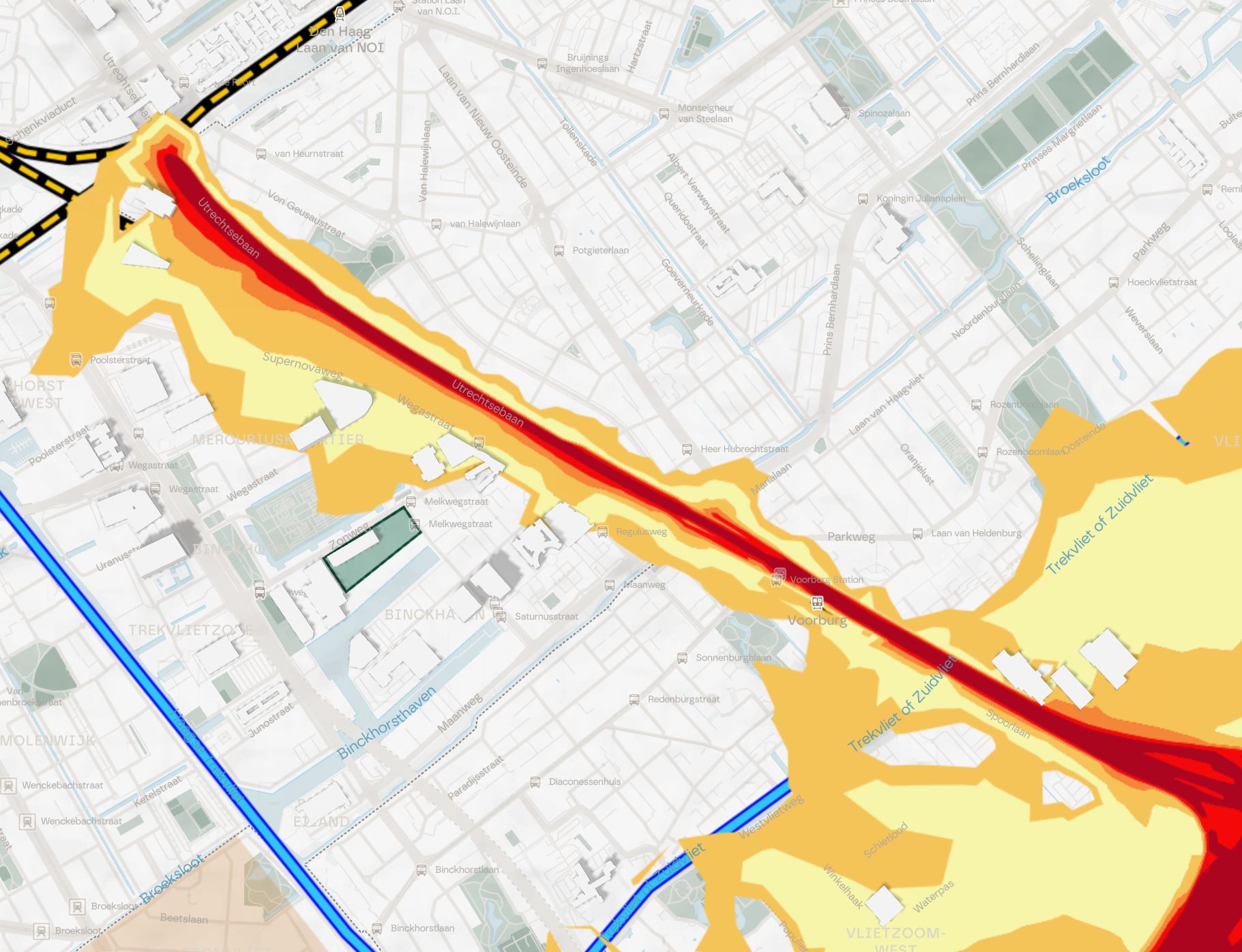
Haleconnect provides INSPIRE-harmonized environmental data across European Union member states. We use it for Dutch road noise data, which follows the EU Environmental Noise Directive (END) and uses standardized Lden and Lnight indicators. This is the same harmonization framework that allows Hektar to handle noise data consistently across our Northern European markets.
Below is every Dutch WMS layer currently active in Hektar, grouped by source and category.
Kadastrale Grens. Dutch cadastral parcel boundaries. The single most important administrative layer for any feasibility study, since parcel geometry determines what can legally be built where.
PDOK INSPIRE CP. INSPIRE-harmonized version of Dutch cadastral parcels. We integrate both the native PDOK Kadastrale Grens layer and the INSPIRE-harmonized CP layer because the two serve different downstream uses; the native version has higher fidelity for Dutch users, while the INSPIRE version is interoperable with cross-border European workflows.
Aardbeving Mercallizone. Earthquake risk zones using the Mercalli intensity scale. Critical in Groningen and surrounding gas-extraction-affected regions, where seismic risk has direct structural design implications.
Brandbaar Natuurgebied. Wildfire-prone natural areas. Relevant for projects adjacent to heathland or coniferous forest, where Dutch fire safety regulations impose specific design requirements.
Spoor Hogesnelheidslijn. High-speed rail network. Imposes noise, vibration, and setback constraints on adjacent residential development.
Spoor Intercitylijn. Intercity rail network. Same considerations as the high-speed lines but with different distance-attenuation profiles.
Tunnel. Tunnel infrastructure. Surface development above tunnels carries specific structural and safety constraints.
Vliegveld Civiel. Civil airports. Civil aviation zones include noise contours and height restrictions that can fundamentally alter what is buildable on a parcel.
Vliegveld Militair. Military airports. Often stricter than civil aviation restrictions, particularly around radar and flight-path zones.
Water Aanlandingslocatie. Water landing locations. Relevant for waterfront feasibility studies and risk planning.
Water Vaarroute. Shipping lanes, canals, and navigation routes. Defines what can be built along and near major Dutch waterways.
Water Wadlooproute. Wadden Sea walking routes. Relevant for sensitive coastal projects in the northern Netherlands.
Water Zeehaven. Sea ports. Industrial and logistics constraints around port-adjacent development.
Weg Autosnelweg. Motorways. Carries the highest noise and air-quality implications for residential proximity decisions.
Weg Autoweg. Expressways. Similar to motorways with different speed-class implications.
Water Watersportgebied. Water sports zones. Useful for understanding the recreational context of waterfront residential projects.
Noise Lden. 24-hour weighted average noise from major roads, including penalties for evening and night periods. This is the indicator Dutch and EU residential noise regulations are written against.
Noise Lnight. Average sound level during night hours (23:00 to 07:00). Particularly decisive for residential typologies, since night-time noise drives the strictest setback and facade-orientation requirements.
Some readers will notice what is not on this list. We do not integrate every available Dutch WMS service, because integration is not a checkbox exercise. Each layer added to Hektar increases maintenance load, runtime complexity, and the cognitive overhead for users. We add a layer when the question it answers is genuinely decisive in early-stage residential feasibility.
The current inventory reflects three priorities. First, anything required for legal certainty about what can be built on a parcel (cadastre, INSPIRE harmonization). Second, anything that constrains residential viability through noise, risk, or proximity (Risicokaart infrastructure, Haleconnect noise). Third, anything that is decisive often enough in our customer projects to justify the integration cost.
Layers we have deliberately not yet integrated include detailed land-use plans (ruimtelijke plannen), heritage and monument data, ecological constraint layers, and specialized infrastructure like district heating networks. Several of these are good candidates for future integration, and prospect feedback drives the order in which we add them.
If you are a Hektar user (or evaluating becoming one) and you need a Dutch data layer we do not yet support, the request process is direct. Email us with the WMS service URL, the layer name, the source provider, and a one-sentence explanation of why it matters for your work. We will evaluate it against our integration backlog and respond with a realistic timeline.
We typically prioritize layer requests based on three factors: how often the data is decisive in early-stage decisions, whether the source is authoritative and well-maintained, and how many of our Dutch users would benefit. A request from one user about a niche layer takes longer than a request supported by three or four developers facing the same gap.
For now, contact us through the standard support channel at the top of parametric.se and include "Data layer request - Netherlands" in your subject line. We respond within two business days.
Why does any of this matter for a generative design platform? Because generative output is only as good as the constraint data feeding it. A generative engine producing residential block configurations without accurate parcel boundaries, real noise contours, and authoritative infrastructure context is just guessing at scale.
The deeper the data integration, the more meaningful the generation. This is the architecture underlying our entire product strategy. The Vinnova-funded research project on detaljplan compliance intelligence applies the same principle to the Swedish regulatory context: data and rules are not validation steps at the end of design, they are constraints at the start of generation.
For Dutch projects, this means that when Hektar produces a feasibility scenario, the building positions respect real cadastral boundaries, the typology selections account for actual noise context, and the parcel divisions reflect authoritative geometric data rather than approximations. That is the difference between a generative tool that produces plausible-looking output and one that produces decision-grade output.
The Dutch layer set is one of our most developed alongside Sweden, Norway, and Denmark. We expect to extend it through 2026 with detailed land-use plan data (ruimtelijke plannen) and selected ecological constraint layers, based on requests from our active Dutch users.
If you are working on a Dutch project and want to evaluate whether Hektar's current data layer coverage is sufficient for your specific use case, we can set up a 30-minute review of your site or portfolio. The answer is sometimes yes, sometimes no, and sometimes "yes with one specific extension we should add." All three are useful information.
For more on how data and regulations connect to generative output, see our Vinnova project announcement. For comparisons of how our data integration approach differs from other feasibility tools, see Hektar vs Forma or the five-tool market overview.


