
Articles
Urban Development
May 13, 2026

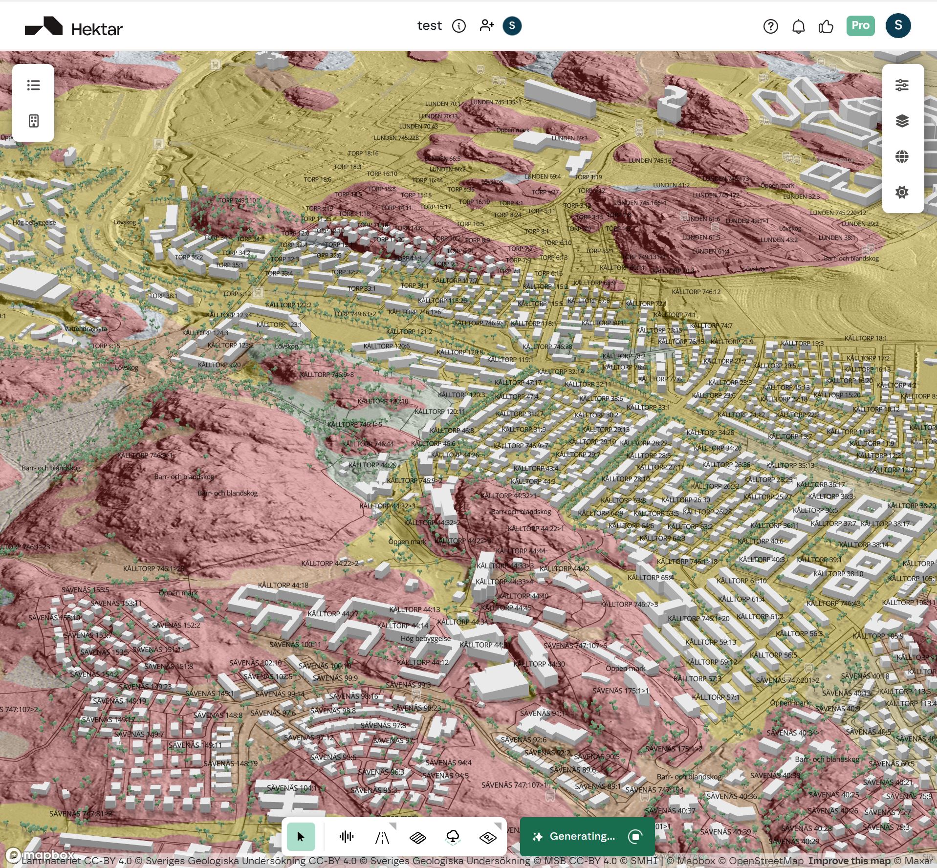

Sweden has one of the world's most mature open geospatial data infrastructures. Lantmäteriet, SGU, MSB, Riksantikvarieämbetet, SMHI, and SCB collectively expose the country's cadastre, geology, flood risk, archaeology, hydrology, and demographic data through public APIs. For an early-stage feasibility platform, this is the raw material that turns generative design from guesswork into something defensible.
Hektar integrates 13 Swedish data layers across six authoritative providers. This post documents every one of them, where each comes from, and why it ended up in the platform.
Anyone who has lost time to a late-stage redesign knows the pattern. The architect proposes a typology. The developer underwrites the financial model. Months later, the geotechnical report flags landslide risk in fine-grained soil. The detaljplan turns out to permit a different building category than originally assumed. A fornlämning sits where the parking garage was planned.
Each of these revelations costs weeks of rework. The cumulative cost is sometimes the project margin itself. Compressing this risk is not a feature; it is the entire reason early-stage feasibility software exists.
The way you compress it is by ingesting authoritative data at the start of the design process rather than at the end. This is the principle behind our Vinnova-funded project on detaljplan compliance intelligence: regulations and data are constraints, not validation steps. The generative engine that produces feasible block configurations operates against real cadastral boundaries, real soil types, real flood zones, real archaeological sites. That is what makes its output trustworthy.
Our Swedish layer stack draws from six providers, each chosen for a specific reason.
The Swedish national mapping, cadastral, and land registration authority. Lantmäteriet is the legal source of truth for property boundaries, detaljplaner (in their visualizable form), and topographic data in Sweden. Every Swedish project starts here, because no other provider is authoritative for the questions Lantmäteriet answers.
The Swedish Geological Survey. SGU publishes soil and bedrock data plus geotechnical hazard layers including landslide susceptibility in fine-grained soils. Critical for any residential project in southwestern Sweden where postglacial clay soils dominate and ground conditions can dictate which typologies are viable.
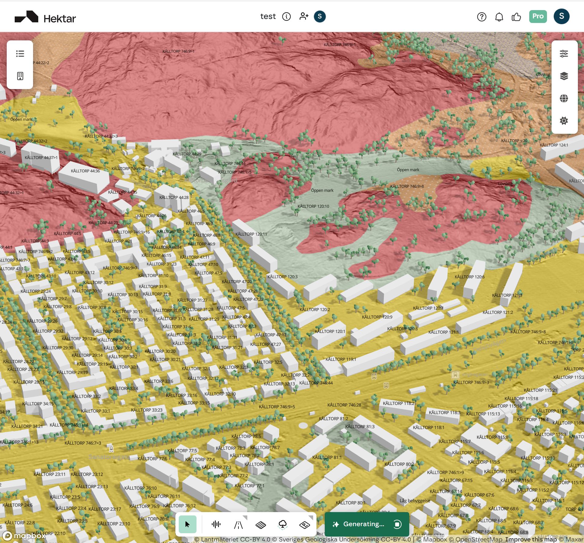
The Swedish Civil Contingencies Agency. MSB maintains the national flood mapping at multiple return periods (100-year, 200-year, calculated maximum). With climate change pushing flood frequency curves, this data has become increasingly decisive for waterfront and low-lying residential feasibility.
The Swedish National Heritage Board. Publishes the national register of archaeological sites (fornlämningar) and ancient monuments. A previously unrecorded fornlämning discovered during construction is one of the most expensive forms of late-stage surprise in Swedish development, and the public register exists precisely to prevent that.
The Swedish Meteorological and Hydrological Institute. Provides hydrological data including drainage basins and catchment areas. Useful for stormwater planning and understanding how a parcel sits within the broader water flow network.
Statistics Sweden. Publishes demographic data including population density at 1 square kilometer resolution. Not directly a regulatory layer, but consequential for residential viability assessments and market analysis at the feasibility stage.
Below is every Swedish WMS or OGC API layer currently active in Hektar, grouped by source.
Detail Plans (Detaljplaner). Visualizable detaljplaner from Lantmäteriet's distribution geodata catalog. The most important administrative layer for any Swedish feasibility study, since the detaljplan determines what may legally be built. Hektar uses this as a baseline regulatory layer in every Swedish project.
Property Regions (Fastighetsindelning). Swedish property boundaries and registration units (registerenhetsområdesytor) via Lantmäteriet's OGC API. Parcel geometry is the foundation of feasibility; everything else is built on top of accurate property boundaries.
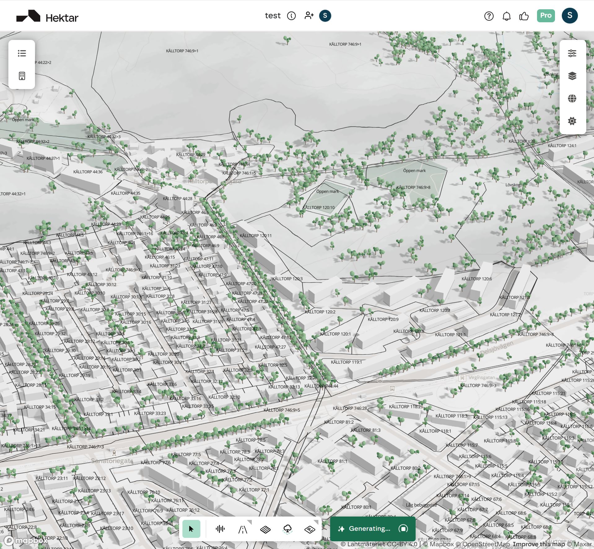
Ground Coverage (Marktäcke). Vegetation and soil cover types describing the landscape character. Useful for early site assessment, particularly for projects on previously undeveloped land where the natural ground cover affects everything from drainage to permission considerations.
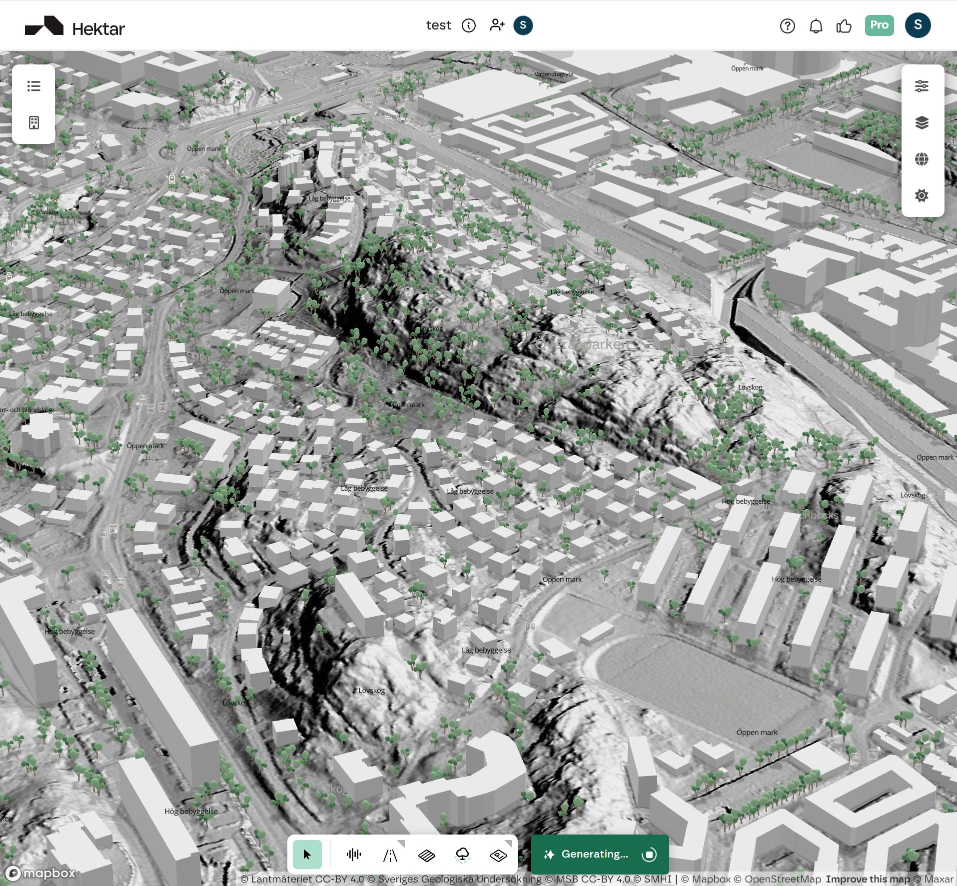
Terrain Shading (Terrängskuggning). Hillshade rendering from Lantmäteriet's elevation model. Provides immediate visual context for site topography during the first sketch.
Terrain Slope (Terränglutning). Computed slope from the same elevation model. Decisive for ground-floor accessibility, drainage strategy, and the economics of grading. Steep terrain changes the cost structure of every subsequent decision.
Soil Types (Jordarter). Soil and bedrock types from SGU's 1:25,000 mapping. The starting point for understanding what foundation strategies will be viable on a site, which directly affects construction cost estimates and building height feasibility.
Landslide Susceptibility (Skredkänslighet). Areas with prerequisites for landslides in fine-grained soils, both shoreline-adjacent and inland. Critical for projects in postglacial clay areas, particularly around the Väner basin and along southwestern Swedish coastlines. A site that triggers this layer often requires expensive geotechnical intervention or different typology choices entirely.
Calculated Maximum Flood. The highest flood level MSB has modeled for the location. Conservative planning boundary for waterfront residential.
200-year Flood. Flood level expected to be exceeded once in 200 years on average. Used in Swedish planning practice as a standard reference for new residential development setbacks.
100-year Flood. Flood level expected to be exceeded once in 100 years. The lower bound for residential flood planning. Modern Swedish planning increasingly references both the 100-year and 200-year levels because climate adaptation pushes the relevant return period upward.
Ancient Monuments (Fornlämningar). Published archaeological sites with varying degrees of legal protection. Hektar applies a refined filter so the layer surfaces sites that are confirmed, damaged, or have active investigation status. A fornlämning on or adjacent to a parcel can require excavation surveys, building setbacks, or in some cases prevent development altogether.
Drainage Basins (Avrinningsområden). Catchment areas showing how water flows through the landscape. Useful for understanding stormwater context and downstream implications of new development.
Population per Square Kilometer. Population density gridded at 1 square kilometer resolution. Provides immediate demographic context: is this an urban infill site, suburban expansion, or rural development? The answer changes both the market and the regulatory expectations.
Looking at this list, three things should be visible.
First, we prioritize legal authority. Lantmäteriet for cadastre and detaljplan, SGU for geology, MSB for flood, Riksantikvarieämbetet for archaeology. We do not aggregate. We do not approximate. We go directly to the agency whose data is the legal source of truth, and we ingest from them via authenticated APIs where required.
Second, we prioritize residential feasibility relevance. Every layer in the inventory contributes to one or more of the questions that early-stage residential development must answer: What may be built here legally? What can be built here geotechnically? What is the noise, flood, and archaeological context? What is the demographic environment?
Third, we prioritize what is decisive rather than what is comprehensive. Sweden publishes hundreds of geospatial data services. We have integrated 13. The criterion is not breadth; it is whether the layer changes early-stage decisions often enough to justify the integration cost.
For honest comparison, here is what is missing from the Swedish stack today.
We have not yet integrated Naturvårdsverket's protected nature layers (Natura 2000, naturreservat, biotopskydd), although this is a high-priority item on our roadmap. We have not yet integrated Trafikverket's planned infrastructure projects, which affect long-term site context. We have not yet integrated detailed kulturmiljö layers beyond the fornlämning register. We have not yet integrated municipality-specific data such as energy networks or planned utility extensions.
Most of these are good candidates and several are being scoped for 2026. The order in which they arrive depends partly on customer demand.
If you need a Swedish data layer that is not in this inventory, tell us. The fastest path is to email us with the WMS or OGC API service URL, the specific layer name, the issuing authority, and a brief explanation of why it matters for your work.
We evaluate layer requests against three criteria: how often the data is decisive in early-stage decisions, whether the source is authoritative and well-maintained over time, and how many Swedish users would benefit. Layers requested by multiple developers facing the same gap move faster than one-off requests.
Contact us through the support channel at the top of parametric.se with "Data layer request - Sweden" in the subject. We respond within two business days.
The reason data layers matter for a generative design platform is structural: the generative output is only as defensible as the data feeding it. A generative engine that proposes residential blocks without checking real detaljplaner is not feasibility software; it is decorative sketching. A platform that ignores soil types when proposing typologies on Swedish postglacial clay is producing scenarios that will fail at the geotechnical review.
This is why our Vinnova project on detaljplan compliance intelligence is not a side initiative. It is core to the product strategy. Data and regulations are not validation steps after the fact; they are the constraint structure that shapes what the generative engine produces in the first place.
For a Swedish project in Hektar, this means that when the platform generates a block configuration, the parcel boundaries are real, the soil types are real, the flood risk is real, the fornlämning context is real, the detaljplan boundary is real. None of it is approximated. The resulting feasibility scenario is the kind of output you can take to a board meeting and defend.
Sweden is our deepest market for both customer adoption and data integration. The 13-layer current stack will grow in 2026, with Naturvårdsverket protected nature data as the next high-priority integration based on requests we have received from our active Swedish users.
If you are working on a Swedish project and want to evaluate whether the current data coverage is sufficient for your specific use case, we can set up a 30-minute review. The answer is sometimes yes, sometimes no, and sometimes "yes if we add this one specific layer." All three are useful information.
For more on why data and regulations belong at the start of design, see our Vinnova project announcement. For the equivalent inventory of our Dutch data layers, see The Netherlands Data Layers in Hektar. For comparisons against other feasibility tools, see Hektar vs Forma.


